
Best Hiking Apps to Track Your Trails and Elevation
Best Hiking Apps to Track Your Trails and Elevation
Technology has made outdoor adventures smarter and safer. With modern hiking apps, you can discover new trails, navigate off-the-grid paths, and monitor your elevation in real-time. This comprehensive guide covers the top hiking apps available today, their key features, pros and cons, and direct download links.
Why Use a Hiking App?
- Accurate trail maps
- Offline navigation
- Real-time elevation data
- Safety tracking (location sharing)
- Trail reviews and user tips
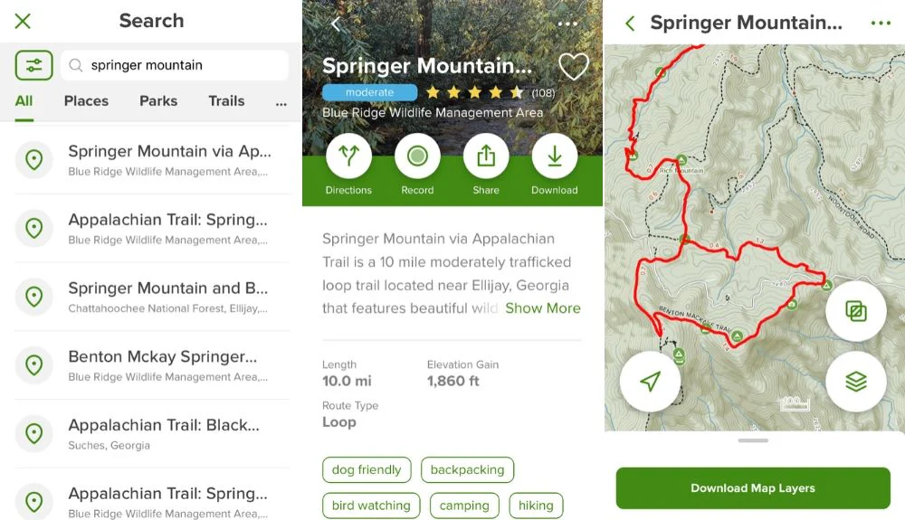
1. AllTrails
- Available On: iOS, Android
- Website: AllTrails
Key Features:
- 350,000+ trails worldwide
- GPS tracking & offline maps (Pro version)
- Trail reviews and photos from users
- Filters for difficulty, length, and dog-friendliness
Pros:
- Massive global trail database
- Easy to use with intuitive interface
- Sync with smartwatches
Cons:
- Some features require a paid Pro version
- Battery consumption can be high on long hikes
2. Komoot
- Available On: iOS, Android
- Website: Komoot
Key Features:
- Route planning with elevation profiles
- Offline maps
- Tailored for hiking, biking, mountain sports
- Community recommendations
Pros:
- Highly detailed elevation and terrain info
- Affordable regional packages
- Voice navigation available
Cons:
- Requires purchase for additional regions
- Fewer trail reviews compared to AllTrails
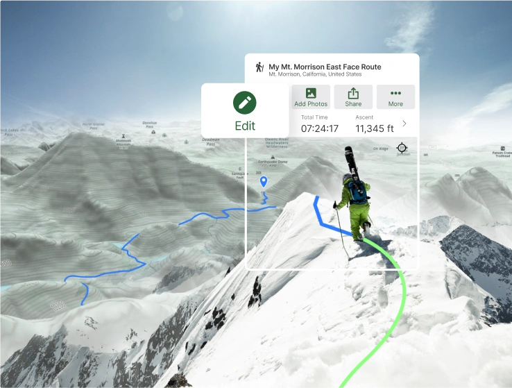
3. Gaia GPS
- Available On: iOS, Android
- Website: Gaia GPS
Key Features:
- Professional-grade topographic maps
- Offline access
- Weather overlays, slope shading, satellite views
- Great for off-trail navigation
Pros:
- Ideal for backcountry hiking
- Variety of map layers
- Detailed elevation and environmental data
Cons:
- Steep learning curve
- Subscription needed for premium features
4. PeakFinder
- Available On: iOS, Android
- Website: PeakFinder
Key Features:
- 3D views of surrounding peaks
- Identifies mountains in real-time using camera view
- Offline database of 650,000 peaks
Pros:
- Unique augmented reality features
- Great for summit identification
Cons:
- Not suitable as a primary navigation app
- Requires GPS and camera access
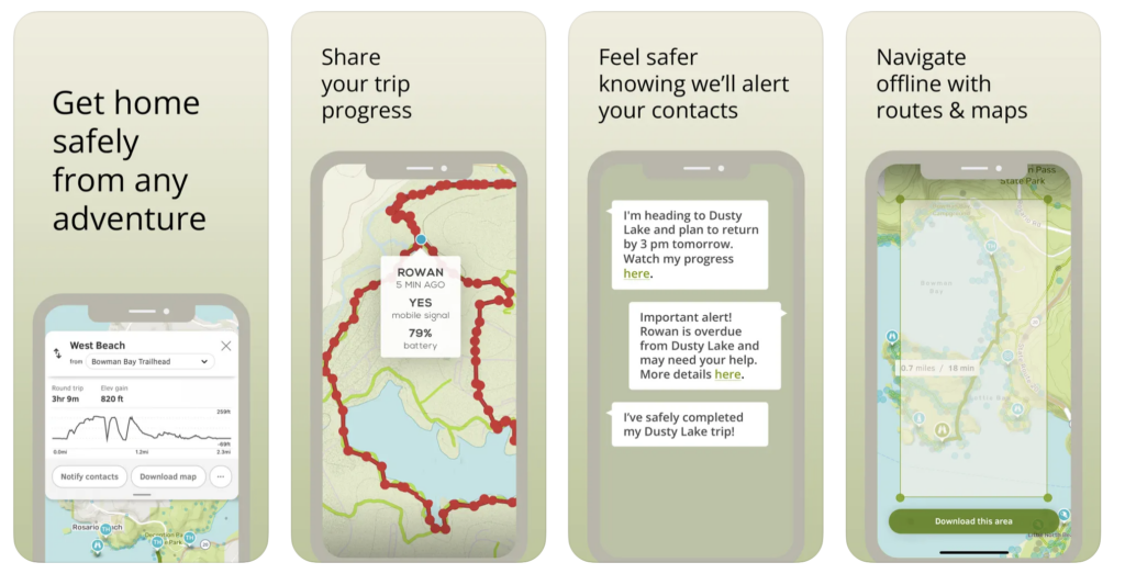
5. Cairn
- Available On: iOS, Android
- Website: Cairn
Key Features:
- Safety-focused app with location sharing
- Find areas with cell coverage
- Real-time progress sharing with emergency contacts
Pros:
- Excellent for solo hikers
- Offers safety alerts
Cons:
- Limited mapping and trail discovery
- Requires subscription for premium features
Comparison Table
| App | Best For | Offline Maps | Elevation Tracking | Free Version | Notable Feature |
|---|---|---|---|---|---|
| AllTrails | Trail discovery | Yes (Pro) | Yes | Yes | User reviews, filters |
| Komoot | Route planning | Yes | Yes | Yes | Custom route planner |
| Gaia GPS | Backcountry navigation | Yes (Pro) | Yes | Limited | Topo & satellite layers |
| PeakFinder | Summit identification | Yes | Yes | No | Augmented reality views |
| Cairn | Hiking safety & tracking | Yes | Yes | Yes | Location sharing |
Tips for Using Hiking Apps
- Download offline maps before your hike.
- Keep your phone in airplane mode to save battery.
- Carry a portable charger for longer treks.
- Double-check trail reviews for seasonal conditions.
- Test the app functionality before your actual hike.
Conclusion
With the right hiking app, your outdoor experience can be safer, more informed, and far more enjoyable. Whether you’re planning a casual nature walk or a multi-day wilderness trek, these apps provide everything from trail discovery to emergency location sharing.
No responses yet